


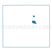
Voting District 0231702000002, Branch County, Michigan
About
Outline

Summary
| Unique Area Identifier | 596074 |
| Name | Voting District 0231702000002 |
| County | Branch County |
| State | Michigan |
| Area (square miles) | 2.52 |
| Land Area (square miles) | 2.51 |
| Water Area (square miles) | 0.01 |
| % of Land Area | 99.55 |
| % of Water Area | 0.45 |
| Latitude of the Internal Point | 41.95134120 |
| Longtitude of the Internal Point | -84.97753370 |
Maps

Graphs
Select a template below for downloading or customizing gragh for Voting District 0231702000002, Branch County, Michigan


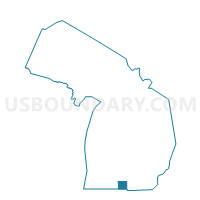
Neighbors
Neighoring Voting District (by Name) Neighboring Voting District on the Map
- Voting District 0231702000001A, Branch County, MI
- Voting District 0231702000003A, Branch County, MI
- Voting District 0231704000001, Branch County, MI
- Voting District 0233228000001, Branch County, MI
Top 10 Neighboring County Subdivision (by Population) Neighboring County Subdivision on the Map
- Coldwater city, Branch County, MI (10,945)
- Coldwater township, Branch County, MI (6,102)
- Girard township, Branch County, MI (1,780)
Top 10 Neighboring Place (by Population) Neighboring Place on the Map
Top 10 Neighboring Unified School District (by Population) Neighboring Unified School District on the Map
Top 10 Neighboring State Legislative District Lower Chamber (by Population) Neighboring State Legislative District Lower Chamber on the Map
Top 10 Neighboring State Legislative District Upper Chamber (by Population) Neighboring State Legislative District Upper Chamber on the Map
Top 10 Neighboring 111th Congressional District (by Population) Neighboring 111th Congressional District on the Map
Top 10 Neighboring Census Tract (by Population) Neighboring Census Tract on the Map
- Census Tract 9513, Branch County, MI (6,419)
- Census Tract 9514, Branch County, MI (4,337)
- Census Tract 9501, Branch County, MI (4,120)
- Census Tract 9515, Branch County, MI (3,044)